


Urban planning can help develop cities with reduced seismic risk
Researchers from Universidad Politécnica de Madrid (UPM) suggest a new methodology to establish urban modifiers that affect the building habitability in seismic risk areas.
What types of buildings do they have greater predisposition to suffer damage after an earthquake? This is what a team of researchers from the Research Group on Earthquake Engineering at School of Land Surveying, Geodesy and Mapping Engineering of UPM is trying to find out.
For this purpose, the researchers carried out a study that took into account parameters of urban planning (urban modifiers) and they were used to identify the typologies of the buildings and classify them according to their habitability after an earthquake. Applying this methodology we could create a visual catalog of buildings and rapidly identify those that could be uninhabitable after an earthquake.
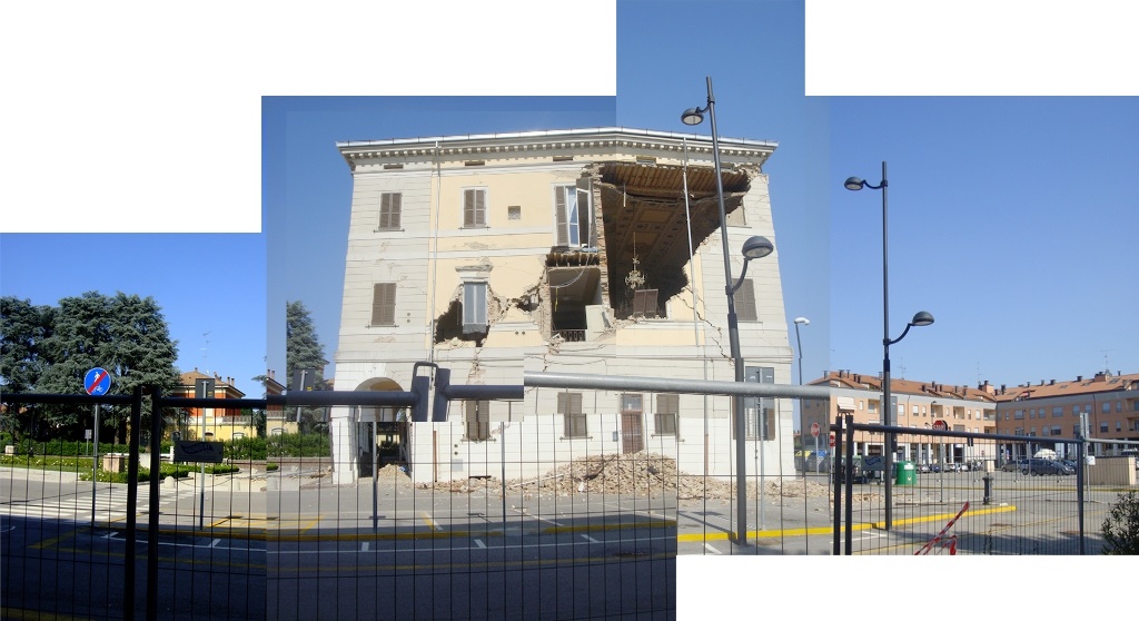
Uninhabitable buildings after suffering structural damage in the earthquake of Emilia Romagna, Italy 2012.
The seismic vulnerability of a building refers to its predisposition to suffer damage after an earthquake. Today there are many studies that classify buildings by taking into account their seismic vulnerability and there are also numerous methodologies that use these typologies or add new ones to obtain the damage of the buildings after an event of this type.
The aim of the project carried out by UPM researchers was to find out whether the urban modifiers were related to habitability. To this end, they developed a classification of the urban parameters that increased the damage after an earthquake and later, after a statistical study and the modifier grouping, they classified the typologies of buildings that could remain uninhabited after an earthquake.
Sandra Martínez Cuevas, a female researcher involved in this study, says “This information would be very valuable for councils and regions that are located in seismic risk areas since it would allow them to catalog their park estate as well as for civil protection that could predict which buildings would remain inhabitable”.
In order to determine the link between the urban modifiers and the damage, the researchers carried out an exploratory study of such modifiers in the city of Lorca to establish its correlation with the damage caused by the 2011 earthquake. They selected three areas of study in the city with a total of 816 buildings and conducted an exhaustive fieldwork to assess the seismic vulnerability. They directly observed the characteristics of each constructive unit.
The buildings were classified according to their structure (concrete or masonry) and their urban modifiers. Besides, they took into account the ground on which the buildings were located and the type of damage to homogeneously compare the data and carry out a statistical study. As a result, an extensive and complete database with information about the constructions of Lorca was obtained and it was implemented in a Geographic information system.
Later, they conducted a correlation analysis to find out the link between the urban modifiers and the habitability and defined an index of discrimination. Having this first analysis, they calibrated the urban modifiers for each type of ground and each structural typology.
Sandra Martínez Cuevas says “this first graduation of the urban modifiers in relation to the damage will allow us to initially influence on the urban regulation in the city of Lorca and give recommendations for urban planning and reduce the damage of possible future earthquakes”.
Finally, researchers studied their contingency table to assess the link between the dependence between two qualitative nominal or ordinal variables. Therefore, from this contingency table, we can assess the urban modifiers and habitability.
With the obtained results, researchers carried out a scale of habitability and added the levels with the associated probability to the damage greater than or equal to 70% on each constructive typology (concrete and masonry) and for each type of ground (hard and soft). Sandra Martínez Cuevas says, “as a result, we obtained diverse building typologies that would give the habitability cartography with at least 70% matching, in other words, we could say with 70% reliability which buildings would be uninhabitable in Lorca if an earthquake with the same characteristics occurred in Lorca as it happened in May 2011 ".
Besides, she adds “by using this method, we can perform mapping analysis of the habitability of buildings that can provide an approach of great interest for mitigation tasks and early response planning”. It is essential to transfer the results to the organisms responsible for c city planning and management of civil protection and emergency in order to develop cities with less seismic risk.
Martínez-Cuevas, S., Benito, M.B., Cervera, J. Morillo, M.C. and Luna, M. Urban modifiers of seismic vulnerability aimed at Urban Zoning Regulation. Bulletin Earthquake Engineering 15 (11): 4719-4750.